
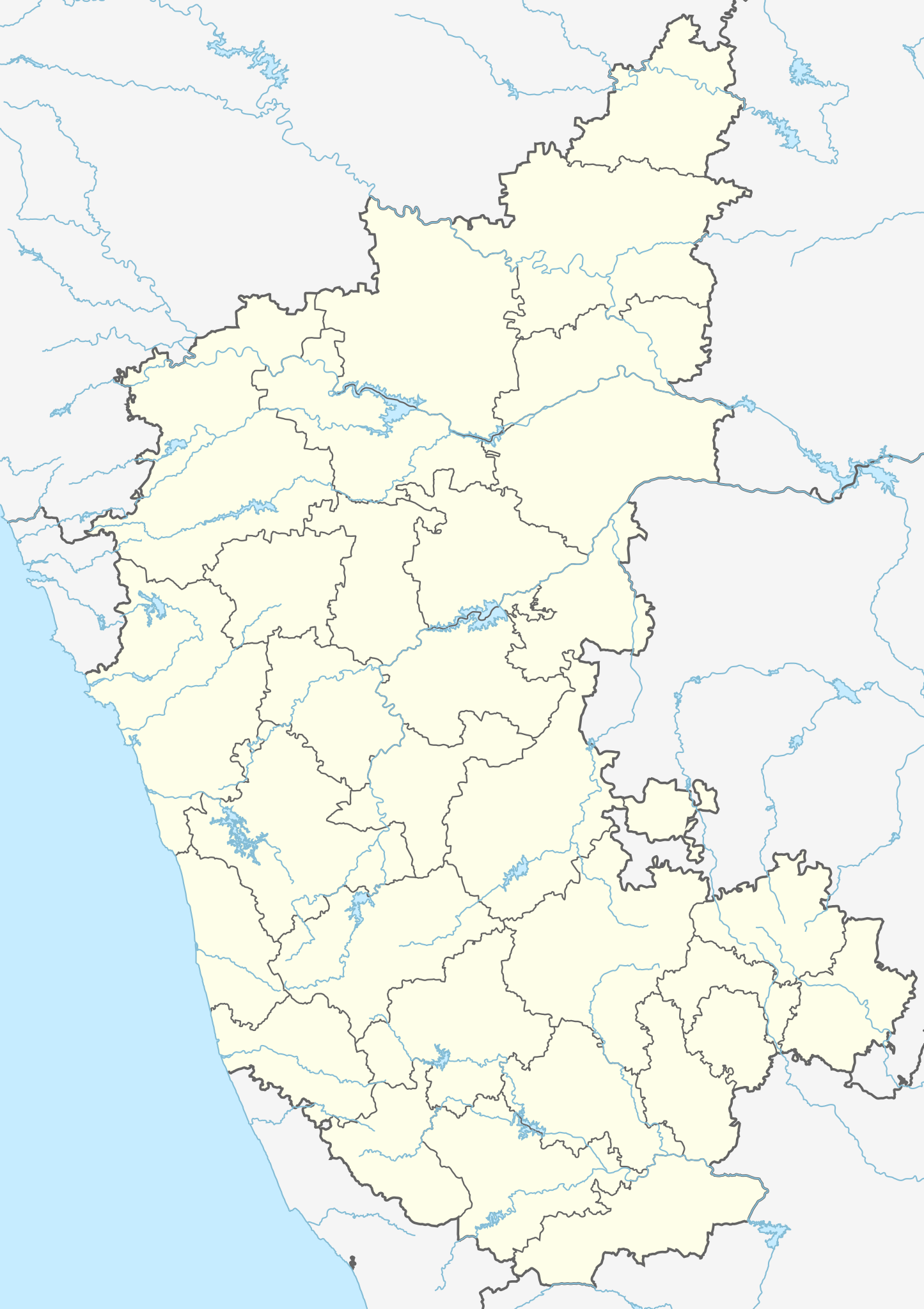
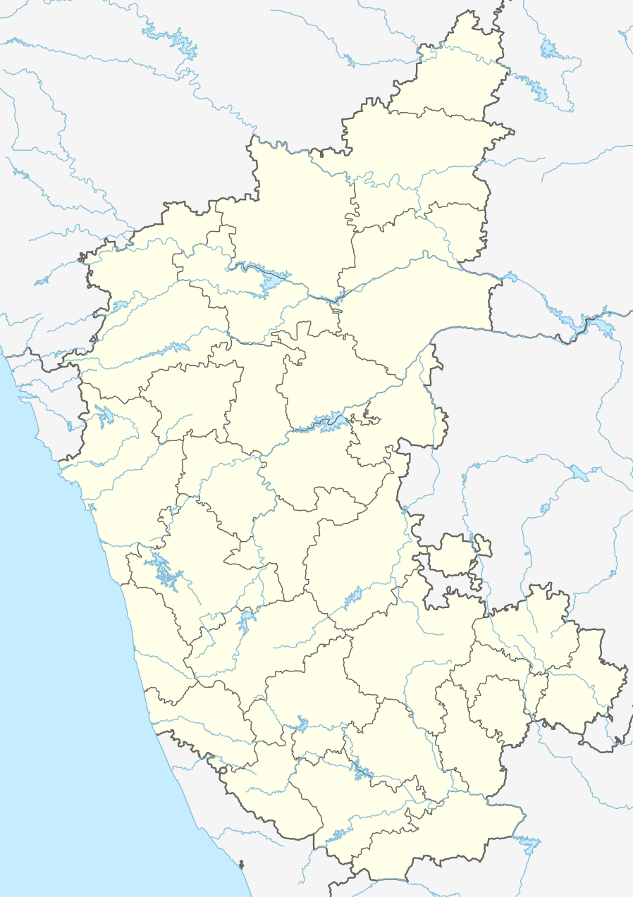
ಚಿತ್ರ:India Karnataka location map.svg

Size of this PNG preview of this SVG file: ೪೨೩ × ೬೦೦ ಪಿಕ್ಸೆಲ್ಗಳು. ಇತರ ರೆಸಲ್ಯೂಶನ್ಗಳು: ೧೬೯ × ೨೪೦ ಪಿಕ್ಸೆಲ್ಗಳು | ೩೩೮ × ೪೮೦ ಪಿಕ್ಸೆಲ್ಗಳು | ೫೪೨ × ೭೬೮ ಪಿಕ್ಸೆಲ್ಗಳು | ೭೨೨ × ೧,೦೨೪ ಪಿಕ್ಸೆಲ್ಗಳು | ೧,೪೪೫ × ೨,೦೪೮ ಪಿಕ್ಸೆಲ್ಗಳು | ೮೯೮ × ೧,೨೭೩ ಪಿಕ್ಸೆಲ್ಗಳು.
ಮೂಲ ಕಡತ (SVG ಫೈಲು, ಸುಮಾರಾಗಿ ೮೯೮ × ೧,೨೭೩ ಚಿತ್ರಬಿಂದುಗಳು, ಫೈಲಿನ ಗಾತ್ರ: ೭೫೯ KB)
ಈ ಫೈಲು ವಿಕಿಮೀಡಿಯ ಕಾಮನ್ಸ್ನಲ್ಲಿ ಇರುವುದು. ಅಲ್ಲಿನ ವಿವರಣೆ ಪುಟವನ್ನೇ ಕೆಳಗೆ ತೋರಿಸಲಾಗಿದೆ. ಕಾಮನ್ಸ್ ಕೃತಿಸ್ವಾಮ್ಯತೆಯಿಂದ ಮುಕ್ತ ಫೈಲುಗಳ ಒಂದು ಆಗರ. ಅಲ್ಲಿ ನೀವೂ ಸಹಕರಿಸಬಹುದು. |
| ವಿವರ |
Location map of Karnataka Geographic limits of the map:
|
| ದಿನಾಂಕ | (UTC) |
| ಆಕರ | |
| ಕರ್ತೃ |
|
| ಇತರೆ ಆವೃತ್ತಿಗಳು |
Derivative works of this file: |
| This is a retouched picture, which means that it has been digitally altered from its original version. Modifications: Created 3 new districts Chikkaballapur, Ramanagara and Yadgir. Changed conventions per WP:WPMAP. The original can be viewed here: Karnataka locator map.svg:
|
ಈ ಕಡತ ಕ್ರಿಯೇಟಿವ್ ಕಾಮನ್ಸ್ Attribution
-Share Alike 3.0 Unported ಪರವಾನಗಿ ಹೊಂದಿದೆ.
- ನೀವು ಮುಕ್ತ:
- ಹಂಚಿಕೆಗೆ – ಕೆಲಸವನ್ನು ನಕಲು ಮಾಡಲು, ವಿತರಣೆ ಮತ್ತು ಸಾಗಿಸಲು
- ರೀಮಿಕ್ಸ್ ಮಾಡಲು – ಕೆಲಸವನ್ನು ಬಳಸಿಕೊಳ್ಳಲು
- ಈ ಕೆಳಗಿನ ಷರತ್ತುಗಳಲ್ಲಿ:
- ವೈಶಿಷ್ಟ್ಯ – ನೀವು ಸೂಕ್ತವಾದ ಕ್ರೆಡಿಟ್ ನೀಡಬೇಕು, ಪರವಾನಗಿಗೆ ಲಿಂಕ್ ಅನ್ನು ಒದಗಿಸಬೇಕು ಮತ್ತು ಯಾವುದೇ ಬದಲಾವಣೆಗಳನ್ನು ಮಾಡಿದ್ದರೆ ಸೂಚಿಸಬೇಕು. ನೀವು ಯಾವುದೇ ಸಮಂಜಸವಾದ ರೀತಿಯಲ್ಲಿ ಮಾಡಬಹುದು, ಆದರೆ ಪರವಾನಗಿದಾರರು ನಿಮ್ಮನ್ನು ಅಥವಾ ನಿಮ್ಮ ಯಾವುದೇ ಬಳಕೆಯನ್ನು ಅನುಮೋದಿಸಿದಂತೆ ರೀತಿಯಲ್ಲಿ ಉಪಯೋಗಿಸಬಾರದು.
- ಇರುವುದರಂತೆಯೇ ಹಂಚು – ನೀವು ರೀಮಿಕ್ಸ್ ಮಾಡಿದರೆ, ರೂಪಾಂತರಗೊಳಿಸಿದರೆ ಅಥವಾ ವಸ್ತುವಿನ ಮೇಲೆ ನಿರ್ಮಿಸಿದರೆ, ನಿಮ್ಮ ಕೊಡುಗೆಗಳನ್ನು ನೀವು ಮೂಲದಂತೆ ಅದೇ ಅಥವಾ ಹೊಂದಾಣಿಕೆಯ ಪರವಾನಗಿ ಅಡಿಯಲ್ಲಿ ವಿತರಿಸಬೇಕು.
Original upload log
This image is a derivative work of the following images:
- File:Karnataka_locator_map.svg licensed with Cc-by-sa-3.0
- 2007-05-06T13:55:02Z Planemad 1630x2356 (231773 Bytes) {{WikiProject_India_Maps |Title=Karnataka locator Map |Description=Map of [[w:Karnataka]] with road and rail lines |Source= [http://aquarium.lipetsk.ru/discovery/India2004/karnataka-map.jpg Karnataka Map], [http://www.indianr
Uploaded with derivativeFX
ಕಡತದ ಇತಿಹಾಸ
ದಿನ/ಕಾಲ ಒತ್ತಿದರೆ ಆ ಸಮಯದಲ್ಲಿ ಈ ಕಡತದ ವಸ್ತುಸ್ಥಿತಿ ತೋರುತ್ತದೆ.
| ದಿನ/ಕಾಲ | ಕಿರುನೋಟ | ಆಯಾಮಗಳು | ಬಳಕೆದಾರ | ಟಿಪ್ಪಣಿ | |
|---|---|---|---|---|---|
| ಪ್ರಸಕ್ತ | ೦೮:೪೦, ೧೬ ಜೂನ್ ೨೦೨೩ | | ೮೯೮ × ೧,೨೭೩ (೭೫೯ KB) | C1MM | c Vijayanagara district |
| ೧೦:೧೧, ೧೩ ಆಗಸ್ಟ್ ೨೦೨೧ |  | ೮೫೧ × ೧,೨೧೧ (೫೮೨ KB) | C1MM | Added more rivers | |
| ೦೯:೦೩, ೧೬ ಜುಲೈ ೨೦೨೧ |  | ೮೫೧ × ೧,೨೧೧ (೫೬೧ KB) | C1MM | Added more accurate district boundaries | |
| ೦೫:೧೧, ೧೫ ಡಿಸೆಂಬರ್ ೨೦೨೦ |  | ೧,೬೩೪ × ೨,೩೬೭ (೩೪೧ KB) | C1MM | Fixed boundaries of Vijayanagara district | |
| ೦೩:೪೦, ೧೫ ಡಿಸೆಂಬರ್ ೨೦೨೦ |  | ೧,೬೩೪ × ೨,೩೬೭ (೩೪೫ KB) | C1MM | Added boundaries of AP/Telangana and rivers | |
| ೦೦:೫೬, ೧೪ ಡಿಸೆಂಬರ್ ೨೦೨೦ |  | ೧,೬೩೪ × ೨,೩೬೭ (೩೪೨ KB) | C1MM | Fixed district boundaries of Ballari and added Vijayanagara district | |
| ೦೯:೨೩, ೨೧ ಏಪ್ರಿಲ್ ೨೦೨೦ |  | ೧,೬೩೪ × ೨,೩೬೭ (೨೮೯ KB) | C1MM | Added rivers | |
| ೨೧:೨೦, ೧೫ ನವೆಂಬರ್ ೨೦೧೦ |  | ೧,೬೩೦ × ೨,೩೫೬ (೨೦೭ KB) | Nayvik | Changed background color | |
| ೨೧:೦೪, ೧೫ ನವೆಂಬರ್ ೨೦೧೦ |  | ೧,೬೩೦ × ೨,೩೫೬ (೨೦೬ KB) | Nayvik | {{Information |Description=Location map of Karnataka Geographic limits of the map: * 18.5°N * 11.0°N * 73.6°E * 78.7°E |Source=*File:Karnataka_locator_map.svg, [http://www.censusindia.gov.in/2011-Images/ADMINI2011.jpg Census In |
ಕಡತ ಬಳಕೆ
More than ೧೦೦ pages use this file. The following list shows the first ೧೦೦ pages that use this file only. A full list is available.
- ಅಬ್ಬನಕುಪ್ಪೆ, ಬೆಂಗಳೂರು ಗ್ರಾಮೀಣ
- ಅರಬಿತಿಟ್ಟು ವನ್ಯಜೀವಿಧಾಮ
- ಆಗ್ರಾರ್ ಚರ್ಚ್
- ಇಬ್ರಾಹಿಂ ರೌಝಾ, ಬಿಜಾಪುರ
- ಉಜಿರೆ
- ಕಕ್ಕಿಂಜೆ
- ಕಣಗನಹಳ್ಳಿ
- ಕನಕಗಿರಿ
- ಕನಕಗಿರಿ ಜೈನ ಕ್ಷೇತ್ರ
- ಕನಕಪೂರ, ಚಿಂಚೋಳಿ
- ಕರ್ನಾಟಕದ ಕೋಟೆಗಳು
- ಕರ್ನಾಟಕದ ಜಿಲ್ಲೆಗಳು
- ಕರ್ನಾಟಕದ ಮೊದಲ ಸೌರ ವಿದ್ಯುತ್ ಸ್ಥಾವರ
- ಕಲಬುರಗಿ
- ಕವಲೇದುರ್ಗ
- ಕಾಗಿನೆಲೆ
- ಕುಂದಾಪುರ
- ಕೂರ್ಗ್ ಕಿತ್ತಳೆ
- ಕೃಷ್ಣರಾಜನಗರ
- ಕೆಮ್ಮಣ್ಣು
- ಕೊಲ್ಲೂರು ಮೂಕಾಂಬಿಕಾ ದೇವಸ್ಥಾನ
- ಗುಂಡೇರಿ
- ಗುರುಪುರ
- ಗುಲ್ಬರ್ಗಾ ಕೋಟೆ
- ಗೇರುಸೊಪ್ಪೆ
- ಗೋಕಾಕ ಜಲಪಾತ
- ಚನ್ನರಾಯನ ದುರ್ಗ
- ಚಾರ್ಮಾಡಿ ಘಾಟಿ
- ಜಮಲಾಬಾದ್
- ಜಿಂದಾಲ್ ವಿಜಯನಗರ ವಿಮಾನನಿಲ್ದಾಣ
- ಜೋಗ
- ದಂಡಿನಮ್ಮ ದೇವತೆ
- ದೇರಳಕಟ್ಟೆ
- ದೇವನಹಳ್ಳಿಯ ಸುಭದ್ರಕೋಟೆ
- ಧಾರವಾಡ
- ನರಸಿಂಹರಾಜಪುರ
- ನಿಡಗುಂದಿ
- ಪಟ್ರಾಮೆ
- ಪಿರಿಯಾಪಟ್ಟಣ
- ಬಂದಾರು
- ಬನ್ನೇರುಘಟ್ಟ ರಾಷ್ಟ್ರೀಯ ಉದ್ಯಾನ
- ಬಲ್ಲಾಳ ರಾಯನ ದುರ್ಗ
- ಬಳ್ಳಾರಿ ವಿಮಾನ ನಿಲ್ದಾಣ
- ಬಸವಕಲ್ಯಾಣ ಕೋಟೆ
- ಬಸವನ ಬಾಗೇವಾಡಿ
- ಬಸ್ರೂರು
- ಬಿಳಿಗಿರಿರಂಗನ ಬೆಟ್ಟ
- ಬೀದರ್ ಕೋಟೆ
- ಬೆಂಗಳೂರು
- ಬೆಂಗಳೂರು ಕೋಟೆ
- ಬೆಟ್ಟದ ಪುರ
- ಬೆಳಗಾವಿ ಕೋಟೆ
- ಬೆಳಗಾವಿ ವಿಮಾನ ನಿಲ್ದಾಣ
- ಬೆಳ್ತಂಗಡಿ ನಿಕಾಯ
- ಬೆಳ್ತಂಗಡಿ ವಲಯ
- ಮಂಗಳೂರು
- ಮಂಗಳೂರು ಜಂಕ್ಷನ್ ರೈಲು ನಿಲ್ದಾಣ
- ಮಂಜರಾಬಾದ್ ಕೋಟೆ
- ಮಂಡಗದ್ದೆ
- ಮಜಲಿ,ಕರ್ನಾಟಕ
- ಮಡಂತ್ಯಾರ್ ಚರ್ಚ್
- ಮರವಂತೆ
- ಮಳಖೆಡ
- ಮಾಕಳಿದುರ್ಗ
- ಮಿರ್ಜಾನ್ ಕೋಟೆ
- ಮಿಲಾಗ್ರಿಸ್ ಚರ್ಚು (ಕಲ್ಯಾಣಪುರ)
- ಮುದಗಲ್
- ಮೂಡಿಗೆರೆ
- ಮೈಸೂರು ಅರಮನೆ
- ಮೈಸೂರು ವಿಮಾನ ನಿಲ್ದಾಣ
- ರಂಗನತಿಟ್ಟು ಪಕ್ಷಿಧಾಮ
- ರಾಬರ್ಟ್ಸನ್ ಪೇಟೆ
- ವನದುರ್ಗ ಕೋಟೆ
- ವಾಮಂಜೂರು
- ವಿಜಯನಗರ
- ಶಾಂತಿನಾಥ ಬಸದಿ, ಜಿನನಾಥಪುರ
- ಸಂ. ಜೋನ್ ಬ್ಯಾಪ್ಟಿಸ್ಟ್ ಚರ್ಚು, ಪೆರ್ಮುದೆ
- ಸಂ. ಪ್ಯಾಟ್ರಿಕ್ ಚರ್ಚು, ಸಿದ್ಧಕಟ್ಟೆ
- ಸದಾಶಿವಗಡ
- ಸನ್ನತಿ
- ಸವದತ್ತಿ
- ಸಿಂದಗಿ
- ಸಿದ್ದಾಪುರ (ಉತ್ತರ ಕನ್ನಡ)
- ಸೊರಬ
- ಹರಿಹರ (ಊರು)
- ಹುಕ್ಕೇರಿ
- ಹುಣಸಗಿ
- ಹುಲಗೂರು
- ಹುಲಿಕುಂಟೆ
- ಹೊನ್ನಾಳಿ
- ಹೊಸರಾಮನಹಳ್ಳಿ
- ಸದಸ್ಯ:1810262vijay/ನನ್ನ ಪ್ರಯೋಗಪುಟ1
- ಸದಸ್ಯ:Alisha Quadros/ನನ್ನ ಪ್ರಯೋಗಪುಟ
- ಸದಸ್ಯ:Archana0123/ನನ್ನ ಪ್ರಯೋಗಪುಟ
- ಸದಸ್ಯ:Madan1710551/WEP 2018-19
- ಸದಸ್ಯ:Teju2friends
- ಸದಸ್ಯ:Teju2friends/Sandbox/3
- ಟೆಂಪ್ಲೇಟು:Location map India Karnataka
- ಟೆಂಪ್ಲೇಟು:ಕರ್ನಾಟಕದ ಕೋಟೆಗಳು
- ಮಾಡ್ಯೂಲ್:Location map/data/India Karnataka
View more links to this file.
ಜಾಗತಿಕ ಕಡತ ಉಪಯೋಗ
ಈ ಕಡತವನ್ನು ಕೆಳಗಿನ ಬೇರೆ ವಿಕಿಗಳೂ ಉಪಯೋಗಿಸುತ್ತಿವೆ:
- ar.wikipedia.org ಮೇಲೆ ಬಳಕೆ
- as.wikipedia.org ಮೇಲೆ ಬಳಕೆ
- azb.wikipedia.org ಮೇಲೆ ಬಳಕೆ
- تومکور
- بنقلور
- عباسی، کارناتاکا
- اودقولام
- پیکلیهال
- اوداجی (هیندوستان)
- اوچیلا, اودوپی دیستریکت
- اوچاواد
- او خاناپور
- ویراهانوماکاناپالیا
- فاجیر (هیندوستان)
- پتالور (هیندوستان)
- پت آماپور
- ویراکامبا
- ویراپور
- وانور (هیندوستان)
- ساتیجری
- ساتانور, ماقادی
- ساتانور, بانقالور
- ساسالاتی
- سارقور
- ساراواد
- ساراپادی
- ساپتاساقار
- سانتور
- سانتکاسالاجر
- مایاکوندا
- ساناتی
- ماویناکر
- ماوالی
- ماتیواد
- کالادکا
- سانیکاتا
- کالکونت
- کالکری
- ماتماری
- سانقاناهالا
- کالجی (هیندوستان)
- سانقامشوارا, کالاقاتاجی
- ماتاداکوروباراهاتی
- ماستیهولی
- کالاسا, کوندقول
- ماسارکال
- ماسابینال
ಈ ಫೈಲ್ನ ಹೆಚ್ಚು ಜಾಗತಿಕ ಬಳಕೆಯನ್ನು ವೀಕ್ಷಿಸಿ.